
Each year, hundreds of thousands of people visit Mendenhall Glacier—an easily accessible glacier near Juneau in Southeast Alaska.
Each year, hundreds of thousands of people visit Mendenhall Glacier—an easily accessible glacier near Juneau in Southeast Alaska. But each year, there is less and less of the glacier to see.
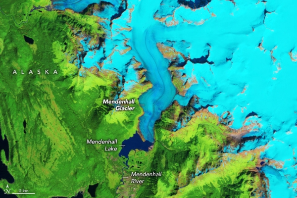
These satellite images show the glacier during summer in 1984 (left) and 2023 (right). Snow and ice are blue in these false-color images, which blend infrared and visible wavelengths to better differentiate areas of ice, rock, and vegetation. False-color also allows a better color match between the two images that were collected by different satellite sensors. The 1984 and 2023 images were acquired by the Thematic Mapper on Landsat 5 and the Operational Land Imager (OLI) on Landsat 8, respectively.
During the time spanned by the image pair, Mendenhall retreated by about 1 mile (1.6 kilometers). In the 1984 image, the glacier’s front ends at the tip of a prominent peninsula in Mendenhall Lake. This proglacial lake collects rain and meltwater and feeds the river flowing south through the Mendenhall Valley, a suburb of Juneau. In the 2023 image, however, much of the glacier terminates on land and only partially reaches the lake. Thinning has also taken a toll on the glacier during the past four decades, causing it to narrow by about 2,000 feet (600 meters) at the bend closest to its front.
Read more at: NASA Earth Observatory
Photo Credit: Wanmei Liang