
On Thursday, NASA released the first data maps from its new instrument launched to space earlier this year, which now is successfully transmitting information about major air pollutants over North America.
On Thursday, NASA released the first data maps from its new instrument launched to space earlier this year, which now is successfully transmitting information about major air pollutants over North America. President Biden and Vice President Harris believe that all people have a right to breathe clean air. Data from the TEMPO mission will help decision makers across the country achieve that goal and support the Biden Administration’s climate agenda — the most robust climate agenda in history.
From its orbit 22,000 miles above the equator, NASA’s TEMPO, or Tropospheric Emissions: Monitoring of Pollution, is the first space-based instrument designed to continuously measure air quality above North America with the resolution of a few square miles.
“Neighborhoods and communities across the country will benefit from TEMPO’s game-changing data for decades to come," said NASA Administrator Bill Nelson. "This summer, millions of Americans felt firsthand the effect of smoke from forest fires on our health. NASA and the Biden-Harris Administration are committed to making it easier for everyday Americans and decisionmakers to access and use TEMPO data to monitor and improve the quality of the air we breathe, benefitting life here on Earth.”
Read more at: NASA Goddard Space Flight Center
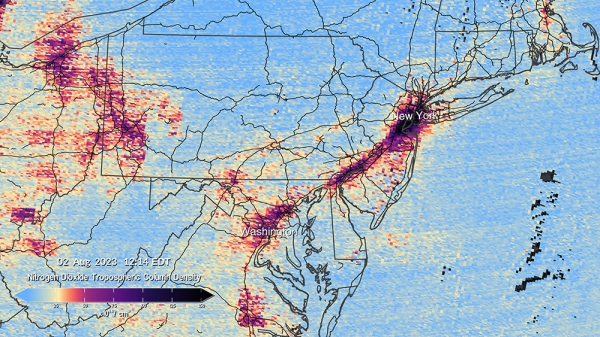
This pair of images shows nitrogen dioxide levels over the DC/Philadelphia/New York region at 12:14 and 4:24 p.m. on August 2, as measured by TEMPO. (Photo Credit: Kel Elkins, Trent Schindler, and Cindy Starr/NASA's Scientific Visualization Studio)